Picture 1 of 1

Gallery
Picture 1 of 1
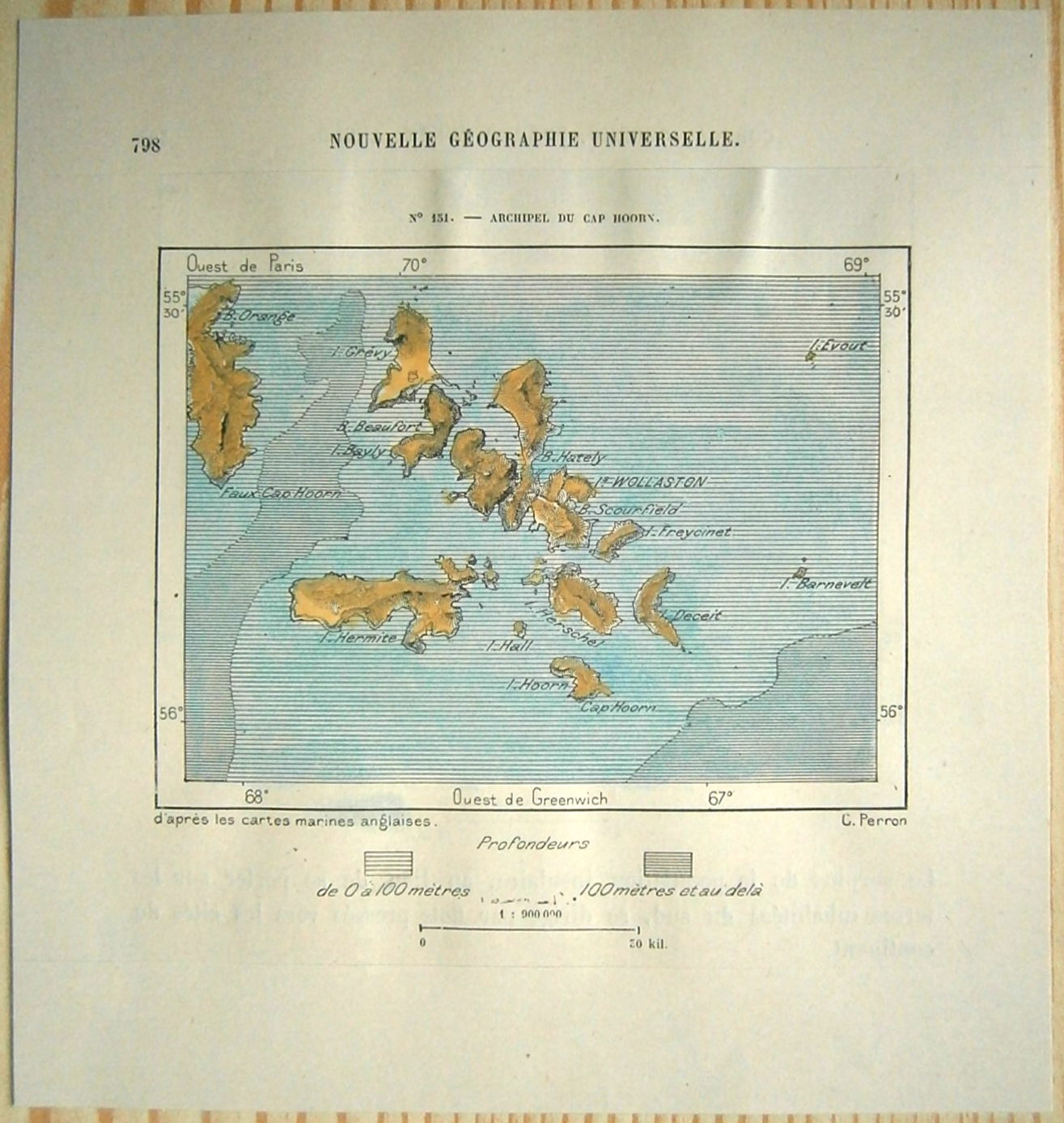
1893 Perron map CAPE HORN ARCHIPEGALO (WOLLASTON ISLANDS), CHILE, #151

US $21.99
ApproximatelyC $30.38
or Best Offer
Condition:
- Buy It Now1893 Perron map CAPE HORN ARCHIPEGALO (WOLLASTON ISLANDS), CHILE, #151
Oops! Looks like we're having trouble connecting to our server.
Refresh your browser window to try again.
Shipping:
US $8.50 (approx C $11.74) Economy Shipping from outside US.
International shipment of items may be subject to customs processing and additional charges.
Located in: Zagreb, HR , Republic of Croatia
Delivery:
Estimated between Wed, May 14 and Mon, Jun 2 to 43230
Please allow additional time if international delivery is subject to customs processing.
Returns:
30 days return. Buyer pays for return shipping. If you use an eBay shipping label, it will be deducted from your refund amount.
Payments:
Shop with confidence
Seller assumes all responsibility for this listing.
eBay item number:394713687794
Item specifics
- Publication Year
- 1893
- Year
- 1893
- Country/Region
- Chile
- Topic
- Maps
Item description from the seller

Popular categories from this store
Seller feedback (8,957)
- 9***9 (64)- Feedback left by buyer.Past monthVerified purchaseGood seller. I have minor reservations about the package - it is too weak - the graphics arrived slightly bent. I assume that the inconveniences can be improved. I recommend
- a***b (1029)- Feedback left by buyer.Past 6 monthsVerified purchaseA beautiful print in excellent condition. Received very quickly from overseas to the USA. Wrapped carefully to avoid damage with modest shipping costs as well. A great seller who can be highly recommended.
- s***_ (856)- Feedback left by buyer.Past yearVerified purchaseitem better than described !!!! Excellent Communication, really nice packaging and FAST FAST shipment!!! A++ SELLER !!! FIVE STARS.1892 Perron map OUTER BANKS OF NORTH CAROLINA, #25 (#395128019468)
More to explore:
- Antique South American Maps & Atlases Chile,
- Chile Antique South America Political Maps,
- Chile Antique South America Atlas Maps,
- Chile Antique South America Folding Maps,
- Antique African Maps & Atlases Cape Town,
- Antique North American Maps & Atlases Rhode Island,
- Antique South American Maps Chile 1800-1899 Date Range Atlases,
- Antique South American Maps Chile 1700-1799 Date Range Atlases,
- Rhode Island Antique North America City Maps,
- Virgin Islands Antique Central American/Caribbean Maps & Atlases
Popular categories from this store
Seller feedback (8,957)
- 9***9 (64)- Feedback left by buyer.Past monthVerified purchaseGood seller. I have minor reservations about the package - it is too weak - the graphics arrived slightly bent. I assume that the inconveniences can be improved. I recommend
- a***b (1029)- Feedback left by buyer.Past 6 monthsVerified purchaseA beautiful print in excellent condition. Received very quickly from overseas to the USA. Wrapped carefully to avoid damage with modest shipping costs as well. A great seller who can be highly recommended.
- s***_ (856)- Feedback left by buyer.Past yearVerified purchaseitem better than described !!!! Excellent Communication, really nice packaging and FAST FAST shipment!!! A++ SELLER !!! FIVE STARS.1892 Perron map OUTER BANKS OF NORTH CAROLINA, #25 (#395128019468)